DRYP: Dryland Water Partitioning model
Model description and structure
The parsimounius water partitioning model is a process-based distributed hydrological model.
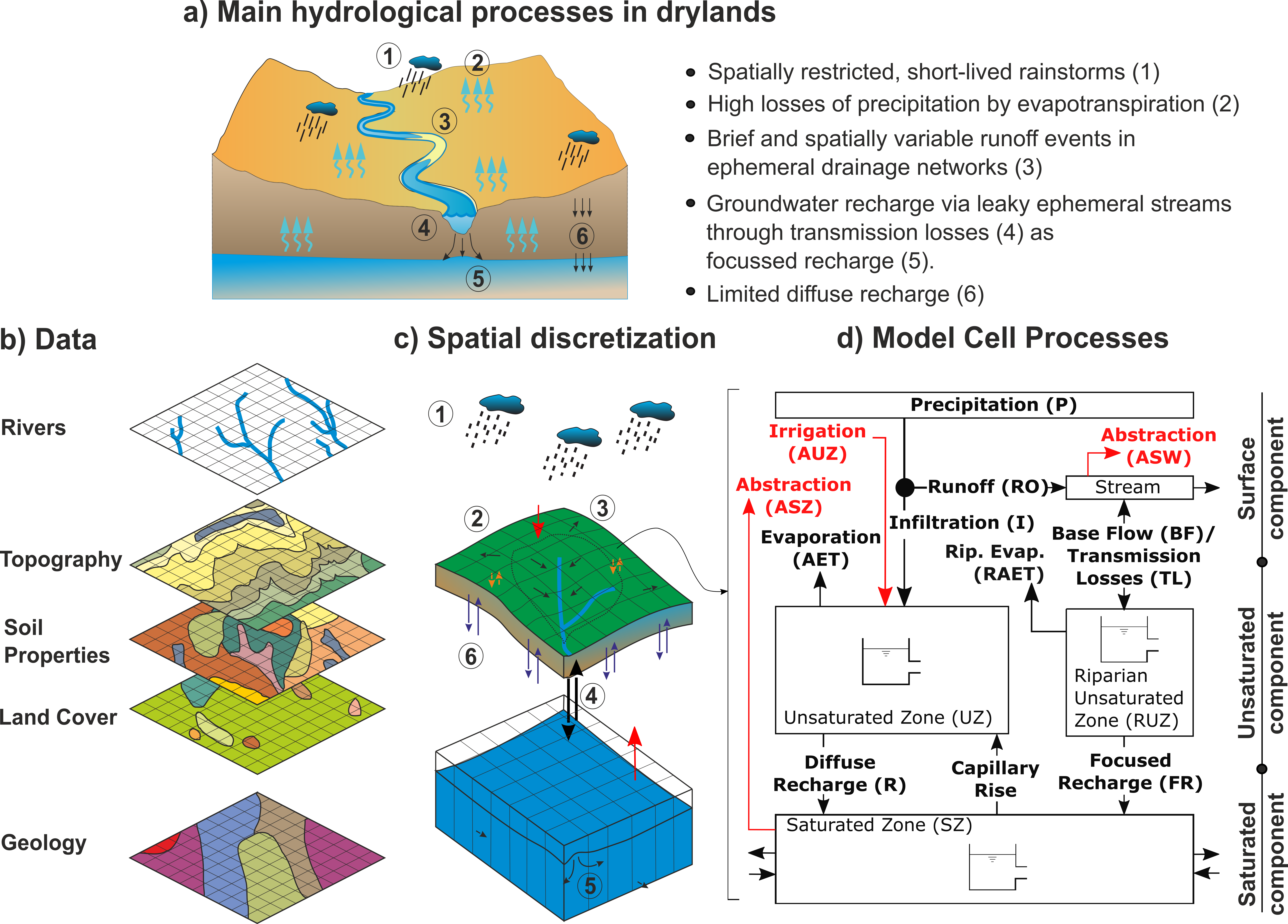
Model Hydrological Parameters
The model uses as input parameter files spatially distributed maps in raster format. If parameter file is not provided, the model will use spatially uniform default values.
A list of parameters required for each component is presented below:
For the surface component:
Digital elevation model (DEM), required (essential).
River network length (in meters) (values greater than zero are specified as rivers), if not available all cells are considered rivers. Default values is the size of model grids.
Flow direction in landlab format (ID of receiving node following landlab indexing), if no available, Landlab will automatically find the direction of flow based on the digital elevation model (DEM).
Model domain, a raster file that can indicating the basin. Default value is 1.0. If not provided, the entire grid will be assumed as the model domain.
Channel witdth (in meters), default value is 10m.
In case of proving a flow direction file, it should follow Landlab conventions. A comprehensive description of landlab flow direction convention can be found here. Noted that Landlab grids are labelled from 0 to n, where n is the number of cells (see here and example below).
ncols        5
nrows        4
xllcorner    574361
yllcorner    3502989
cellsize     1000
NODATA_value  -9999
15 16 17 18 19
10 11 12 13 14
5 6 7 8 9
0 1 2 3 4
Flow direction raster files must have as values the number of the next downstream cell. If a cell value of the flow direction file has the same value of index, it means that it is a sink point.
For the subsurface component the following parameters can be provided, if not availble default values will be used:
Rooting depth in mm, default value 1000mm
path_uz_theta_wp, default value 0.1
total available water wilting point (AWC), default value 0.10
Porosity (n_e), default value 0.40
Standard deviation of the saturated hydraulic conductivity, $sigma$
Infiltration at saturated conditions, ($K_{sat}$) in mm/h, default value 1.0 mm/h
Water content at residual capacity, $theta_r$
Exponent of the water retention function (soil particle distribution), $b$ default value 10.5.
Suction head, $psi$, default value 300mm
For the groundwater component
factor_sz_kksat, $Ks_{GW}$, default value 1 [m/h]
Aquifer specific yield, $Ks_{GW}$, default value 0.01 [-]
Groundwater model domain, optional, in case that groundwater catchment is different than surface catchment.
Initial water table, default value is specified at 1 meter below the rooting depth.
Head boundary conditions (optional)
Flux boundary conditions (optional)
Streambed elevation, default value is 5m below the surface elevation.
Forcing datasets
DRYP requires time series as model forcing datasets. Precipitation and potential evpotranspiration must be provided in order to run the model, otherwise it will throw an error. Dataset can be spatially variable data as netCDF files, or uniform values over the whole model domain by providing a csv file.
Within the DRYP Settings file under “READING”-“data_reading” then “pre”/”pet, you can specify the type of METEO file you are using as such: - 0 for csv files - 1 for netCDF files - 2 for YEARLY netCDF files - 3 for MONTHLY netCDF files - 4 for DAILY netCDF files - 5 for ensamble netCDF files
It should be noted that if you are running the main cuwalid system (e.g. run_cuwalid() function), these settings will be changed automatically to match what is required from the output of Storm and stoPET.
Model outputs
Output variables for each model component are summarised below, the name of the variable is in brackets. Units of time depends on model settings, for example months.
Surface component:
Runoff (run), in mm/month
Infiltration rate (inf, in mm/month)
Transmission losses (tls), m3/month
Streamflow (dis), m3/month
surface water storage, it includes rivers (ssz), m3/month
Subsurface and riparian component:
Soil and riparian Water content (tht), m3/m3
Actual evapotranspiration from hillslope and riparian area (aet), mm/month
Groundwater diffuse (drh) and focused (fch) recharge, mm/month
Groundwater component:
Water table elevation (wte), m.
groundwater discharge (gdh), m3/month
capillary evapotranspiration (egw), mm/month
total water storage deviation (twsc), m/month
Grodded temporal data:
The user can store the following data as NETCDF format:
Gridded temporal data at hillslope cells, files with the suffix *_grid*. By default containing the following variables:
pre : Precipitaion
pet : Potential evapotranspiration
eat : Actual evapotranspiration
tht : soil water content
rch : Total groundwater recharge
wte : Water table elevation
gdh : Groundwater discharge
egw : Groundwater Evapotranspiration
dis : Streamflow
inf : Infiltration
run : Runoff
twsc : Total water storage change
Gridded temporal data at riparian/stream cells, files with suffix *_gridrp*. By default containing the following variables:
pre : Precipitaion
pet : Potential evapotranspiration
eat : Actual evapotranspiration
tht : soil water content
rch : Total groundwater recharge
gdh : Groundwater discharge
egw : Groundwater Evapotranspiration
inf : Infiltration
run : Runoff
Gridded temporal data maximum daily values at hillslope cells, files with suffix *_gridvmax* By default containing the following variables:
tht : soil water content riparian zone
rch : Focused groundwater recharge
eat : Actual evapotranspiration
Gridded temporal data maximum daily values at riparian/stream cells, files with suffix *_gridrmax* By default containing the following variables:
dis : Streamflow
- Gridded temporal data water bodies, files with sufix *_gridpnd* By default containg the following variables:
vpd : Total volume of water available - ponds
epd : Evaporation - ponds
apd : Total abstractions - ponds
Rasted data:
DRYP stores as raster files .ASC, at the end of the simulation, the following variables:
wte : water table elevation
tht : soil and riparian water content
Vo : surface water bodies storage
Qo : channel storage
Model parameters and setting files
Model input files are json, which can be created by using a text editor like notepad or code editor like Visual Studio Code.
Input parameter file
All filename’s parameters must be listed in model parameters file, which is further explained below, However, if a parameter filename is not provided, the default values will be used as model parameters.
The model is under development therefore some components are still not available (e.g. abstractions and irrigation are not yet available).
Meteorological data required as forcing dataset must be provided. Information can be provided in netCDF format in order to take into account the spatial variability, or it can be a “.csv” file which in turn will assume a uniform rate over the entire model domain (not common). Filenames of the forcing datasets should follow the format specified in the paramter setting file (see next section), and it will depend on the numbers of files provided. If there is only one file, the name of the file can be written directly on the files, but if there are multiple files it will depend on the frequency. Yearly files must have the month and the year specified as numbers (e.g. IMERG_2000-02.nc), whereas yearly files must have only the year specified in numbers (e.g. IMERG-2000.nc). In the input parameter file, the filename field must contain YYYY and/or MM for monthly or yearly datas, as it is shon in the the following examples:
forcing/YYYY/MM/IMERG-YYYY-MM.nc for monthly files,
forcing/IMERG-YYYY_final.nc for yearly files
For the groundwater component, boundary conditions can be specified as head and flux boundary conditions. A raster file of head/flux must be provided if boundary conditions are considered in the model. The raster file will consider a boundary condition any value different that -9999. If boundary files are not provided, zero flux boundary conditions will be assumed.
To print results at specified locations a file listing the x and y coordinates of the each point must be provided as input file. This file must have at least one point listed and it must be located inside the model domain, otherwise an exception error will be raised. More details about the format and specifications about output files is provided in section ref{Coutput}
Result at different locations of each model component can be obtained by providing a file containing a list of coordinates. This should be specified in a comma separated format (e.g. .csv) with column heads specified as North and East for the y and x, respectively. If a coordinate is not located inside the model domain, the simulation will stop. Note that at least one point coordinate should be specified, otherwise, an error will be produced.
Coordinate files can be specified under the ‘OUTPUT’ in the main configuration file:
Point result file are named with the model name followed by aletter p and the name of the variable at the end.
Model variable name’s and codes stored for point result files, for filename see table
Surface component
dis, Discharge
tls, Transmission losses
inf, infiltration excess
Unsaturated zone
tht, soil moisture
aet, actual evapotranspiration
rch, recharge, diffuse and foccused recharge
Saturated zone
wte, water table elevation
Point result files are time series with the first column specified as time with head ‘Date’. The number of columns of result files depend on the number of points specified in the coordinate files defined above. Columns are label depending on the component and variable (see ref{tab:point_files}) followed by number starting by zero (e.g. for discharge, the file model_name_p_dis.csv will contain the following columns, Date’ for time and ‘dis_0’, ‘dis_1’, .. etc. for discharge values)
DRYP automatically save spatially averaged fluxes and water content of model compartments. The name of the this result file has the suffix texttt{avg} and the end. Results are saved at time steps specified for the surface component.
Average results are saved in a comma separated file that can be opened in microsoft excel or any text editor. The document contains the following information which is specified by codes for each variable in the first line:
pre, precipitation,
pet, potentiial evapotranspiration
rch, recharge,
dis, discharge,
aet, actual evapotranspiration,
tht, soil water content,
twsc, groundwater storage,
egw, capillary evaporation
bc, flux at boundary condition
tls, transmission losses